|
Yellowstone National Park Planning
a Visit | Visiting
Online | Nature
| History | Kids'
Stuff | Technical
| Publications
|
| Sulphur
Fire
Yellowstone National Park |

This page may not be updated daily because there may be no new fire activity to report. Started: 15 August / Out: UTMs: 546.5 x 4943 The Sulphur Fire,
started by lightning, was reported on August 15th. This fire is located
across the river from Mud Volcano, more than a mile from the road, and
is visible at times. The fire is currently estimated at 5 acres. The fire
is being closely monitored throughout the day.
Update - 24 Aug - Fri The Sulphur fire continues to spread slowly
through surface fuels. Heavier continuous fuels exist to the north/northeast,
but the fire will have a hard time getting there under current rates of
spread. The fire will be manned by two monitors who will GPS the perimeter.
It is estimated to be 6 acres in size and managed for resource benefits.
Update - 25 Aug - Sat Extreme heat build-up was again observed
in the ground fuels as the fire made an upslope run to the east along the
south flank. Short-duration crown fire was observed beginning about 4:00
pm. The fire is spotting ahead of itself, and these spots will probably
get active tomorrow and continue upslope in an easterly direction. The
fire was mapped at 42 acres and is being managed for resource benefit.
Update - 26 Aug - Sun More torching and short-duration crown
fire runs were observed, although direction of spread shifted from directly
east to southeast in response to west/northwest winds. The head of the
fire has gotten progressively wider as numerous spots ahead of the main
fire have burned together. Ground fuels continue to hold the heat in advance
of the daily burn period, and jackpiles were actively burning throughout
the night. The fire crossed the ridge upslope to the east via spotting
very late in the burn period. The fire was mapped in mid-afternoon at 250
acres.
Update - 27 Aug - Mon Plenty of heat build-up and
frequent torching was observed at the head of the fire. Unburned fuels
within the perimeter also torched on occasion. The south flank made short-duration
crown runs as downdrafts from a passing thunder cell influenced local fire
behavior. The fire was mapped at 380 acres.
Update - 28 Aug - Tues Spread was observed to the north, south,
and east. The south flank slowly backed down the slope, while the northeast
flank continued to move upslope with short-duration crown runs and spotting.
The upslope head of the fire continues to widen, and intense heat is being
generated there in the ground fuels. Plenty of unburned fuels remain within
the perimeter, which is mapped at 540 acres.
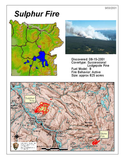
Update - 30 Aug - Thurs All flanks of the fire were again active today. Fire spread was observed to the northeast, mostly by isolated torching and spotting out ahead. Expansion on the east flank was mostly due to continued backing down slope. The west flank similarly increased by spotting out as well. One spot fire 0.6 miles to the northeast of the main body became active again, but activity was mainly confined to the ground fuels. The fire was mapped at 700 acres, but plenty of unburned fuels remain within the established perimeter. Update - 3 Sept - Mon The fire was mapped today at 825 acres,
The fire was particularly active on its western flank, where it crossed
a drainage with a limited rated of spread. Monitors continued to collect
live fuel moisture sampling and observe fire behavior today.
Update - 5 Sept - Wed Smokes were evident all along the perimeter
as well as the interior of the burn. One hotspot on the northwest flank
saw the occasional torching tree. The fire remains at 825 acres.
back to Gallery 13 Planning a Visit | Table of Contents | Visiting Online | Nature | Technical | Publications |