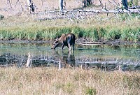
A
Moose. This one was just south of Canyon Junction. For some
reason I usually see moose there.
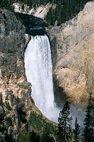 The
Lower Falls of the Yellowstone again, looking very relaxed. Maybe
because it was late summer and the river was low? I have a couple
of winter shots of it up here and here
if you care to look at them. This was taken from near Artist Point,
along the South Rim Trail, near the start of our big hike that day.
We walked along the rim of the Canyon and saw...
The
Lower Falls of the Yellowstone again, looking very relaxed. Maybe
because it was late summer and the river was low? I have a couple
of winter shots of it up here and here
if you care to look at them. This was taken from near Artist Point,
along the South Rim Trail, near the start of our big hike that day.
We walked along the rim of the Canyon and saw...
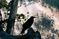 ...Mr.
Raven sitting in a tree. After a little while we got to Artist Point
where we looked at the canyon and the Lower Falls. I looked down
and saw....
...Mr.
Raven sitting in a tree. After a little while we got to Artist Point
where we looked at the canyon and the Lower Falls. I looked down
and saw....
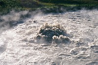
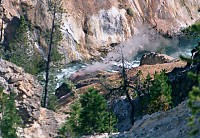 An
unnamed geyser below the Artist Point Overlook, along the banks of the
river. The Grand Canyon of the Yellowstone is there because the rocks
have been altered by hot spring activity. Like many parts of Yellowstone
it is a thermal area, a very old one. The hot water and steam have
turned the solid lava to a crumbly clay like type of stuff, which made
it easier for the Yellowstone River to dig out the canyon. It
also is what gave the rocks here their brilliant colors. There are
many hot springs still active in the canyon, and several of them are geysers.
According to The Geysers of Yellowstone (T. Scott Bryan, 3rd edition,
wonderful book go buy it) none of the ones near Artist Point are named.
This one was erupting every few minutes for maybe 15 or 30 seconds, hard
to tell how high as it is hundreds of feet down in the canyon. It
had a very broad eruption from a crater.
An
unnamed geyser below the Artist Point Overlook, along the banks of the
river. The Grand Canyon of the Yellowstone is there because the rocks
have been altered by hot spring activity. Like many parts of Yellowstone
it is a thermal area, a very old one. The hot water and steam have
turned the solid lava to a crumbly clay like type of stuff, which made
it easier for the Yellowstone River to dig out the canyon. It
also is what gave the rocks here their brilliant colors. There are
many hot springs still active in the canyon, and several of them are geysers.
According to The Geysers of Yellowstone (T. Scott Bryan, 3rd edition,
wonderful book go buy it) none of the ones near Artist Point are named.
This one was erupting every few minutes for maybe 15 or 30 seconds, hard
to tell how high as it is hundreds of feet down in the canyon. It
had a very broad eruption from a crater.
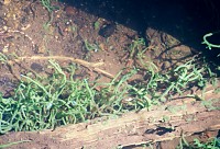 We
continued on our way to Ribbon Lake, and to try to see Silver Cord Cascade
from the south rim. Silver Cord Cascade is the highest waterfall
in the park at over 1000 feet. It turns out that the canyon
is too steep, and the cascade is in sort of a fold in the canyon wall,
so you can't see it from that side. This is some interesting looking
algae growing in the creek that froms Silver Cord. It looks a lot
like some of the weird siphonous algae that grows in the Atlantic Ocean
where I live in Florida. Just goes to show that not all the interesting
algae in Yellowstone lives in hot springs.
We
continued on our way to Ribbon Lake, and to try to see Silver Cord Cascade
from the south rim. Silver Cord Cascade is the highest waterfall
in the park at over 1000 feet. It turns out that the canyon
is too steep, and the cascade is in sort of a fold in the canyon wall,
so you can't see it from that side. This is some interesting looking
algae growing in the creek that froms Silver Cord. It looks a lot
like some of the weird siphonous algae that grows in the Atlantic Ocean
where I live in Florida. Just goes to show that not all the interesting
algae in Yellowstone lives in hot springs.
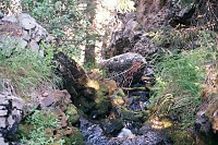 The
brink of Silver Cord Cascade. My little sister got closer to it,
but I was more pudent. We spent a few minutes wondering if she fell
into the canyon.
The
brink of Silver Cord Cascade. My little sister got closer to it,
but I was more pudent. We spent a few minutes wondering if she fell
into the canyon.
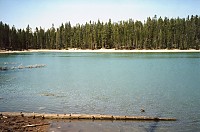
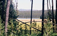 We
eventually did make it to Ribbon Lake.
We
eventually did make it to Ribbon Lake.
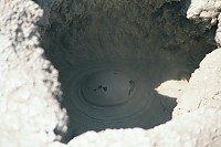 After
Ribbon Lake we generally headed back. Guessing from the maps we had
it seemed that we might find more thermal areas if we took the Wapiti Lake
Trail back rather than the Clear Lake Trail, so we did. There were
several scattered along this section of trail. It looked like they
were mostly mudpots, but that because of dry conditions (it was late summer)
most of them had dried up, had only steam at best. Mudpots form when
acidic steam rises through a wet place. The acids and heat dissolve
the rocks into clay. This mudpot did have a bit of water left, and
we got to watch the bubbling hot mud for a while.
After
Ribbon Lake we generally headed back. Guessing from the maps we had
it seemed that we might find more thermal areas if we took the Wapiti Lake
Trail back rather than the Clear Lake Trail, so we did. There were
several scattered along this section of trail. It looked like they
were mostly mudpots, but that because of dry conditions (it was late summer)
most of them had dried up, had only steam at best. Mudpots form when
acidic steam rises through a wet place. The acids and heat dissolve
the rocks into clay. This mudpot did have a bit of water left, and
we got to watch the bubbling hot mud for a while.
 After this the hike kind of went downhill. Not literally, literally it
was up and down. I discovered a huge blister on my left heel, and
had to walk the last few miles barefoot. That is what I get for never
wearing shoes I guess. That put a damper on future hikes, I was in
sandalls until the last day of the trip. We backtracked a bit to
see Clear Lake, except for my sister, who was too tired to make it down
the hill to the lake. Clear Lake is oddly colored, and looks like
it is to a large extent hot spring runnoff. There are some small
thermal areas right in the nebighorhood. Mom got this picture, I
was out of film by this point.
After this the hike kind of went downhill. Not literally, literally it
was up and down. I discovered a huge blister on my left heel, and
had to walk the last few miles barefoot. That is what I get for never
wearing shoes I guess. That put a damper on future hikes, I was in
sandalls until the last day of the trip. We backtracked a bit to
see Clear Lake, except for my sister, who was too tired to make it down
the hill to the lake. Clear Lake is oddly colored, and looks like
it is to a large extent hot spring runnoff. There are some small
thermal areas right in the nebighorhood. Mom got this picture, I
was out of film by this point.
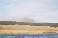 After
our hike we decided to drive south and see the Mud Volcano area.
Right across Hayden Valley from Mud Volcano was this fire. I found
out after I got back and checked out the Yellowstone
Fire Site that it was the Sulphur Fire. Check the site out, it
is way cool, has reports, maps, lots of pictures, including a shot of the
very tree where this fire started. It was started by lightning, and
at this point only burning on the ground. It eventually grew to
825 acres on September 5 when I wrote this, was still burning strong, and
has jumped into the crowns of the trees. Since it was a natural fire
and not threatening anything in particular, it was allowed to burn unmolested.
In fact at pullouts along the road there were big signs saying "natural
fire do not report". At times there were rangers at the pullouts,
no doubt explaining about the fire. We only saw one other fire on
this trip, north of Fishing Bridge (the Stone Fire), but evidently there
were about half a dozen burning in various parts of the park while we were
there.
After
our hike we decided to drive south and see the Mud Volcano area.
Right across Hayden Valley from Mud Volcano was this fire. I found
out after I got back and checked out the Yellowstone
Fire Site that it was the Sulphur Fire. Check the site out, it
is way cool, has reports, maps, lots of pictures, including a shot of the
very tree where this fire started. It was started by lightning, and
at this point only burning on the ground. It eventually grew to
825 acres on September 5 when I wrote this, was still burning strong, and
has jumped into the crowns of the trees. Since it was a natural fire
and not threatening anything in particular, it was allowed to burn unmolested.
In fact at pullouts along the road there were big signs saying "natural
fire do not report". At times there were rangers at the pullouts,
no doubt explaining about the fire. We only saw one other fire on
this trip, north of Fishing Bridge (the Stone Fire), but evidently there
were about half a dozen burning in various parts of the park while we were
there.
 We
walked the Mud Volcano Trail that evening. It is an easy and short
trail with a fine guide available at the begining of the trail. The
springs at mud volcano are acidic and quite different than those in say
the Upper Geyser Basin. The sulpher laden steam was wonderful for
the sinuses, which were not used to the dry, thin air. The portion
of the area around Churning Cauldron has been heating up in recent years,
the springs more active and the ground itself heating and killing trees.
Churning Cauldron itself was looking particularly vigorous, so I snapped
it's picture.
We
walked the Mud Volcano Trail that evening. It is an easy and short
trail with a fine guide available at the begining of the trail. The
springs at mud volcano are acidic and quite different than those in say
the Upper Geyser Basin. The sulpher laden steam was wonderful for
the sinuses, which were not used to the dry, thin air. The portion
of the area around Churning Cauldron has been heating up in recent years,
the springs more active and the ground itself heating and killing trees.
Churning Cauldron itself was looking particularly vigorous, so I snapped
it's picture.
back to the Yellowstone Pictures Page